***********
เนื้อความส่วนที่เหมือนกับเดิมไม่แปล แต่คงไว้เพื่อรักษาใจความของเนื้อข่าวใหม่นะครับ **************
10 more questions Russian military pose to Ukraine, US over MH17 crash
10 คำถามเพิ่มเติมจากกองทัพรัสเซีย ยื่นต่อยูเครนและสหรัฐในเรื่องการตกของ MH17
Published time: July 21, 2014 23:23
Edited time: July 22, 2014 13:56 Get short URL
Russia Military at the media conference in Moscow,
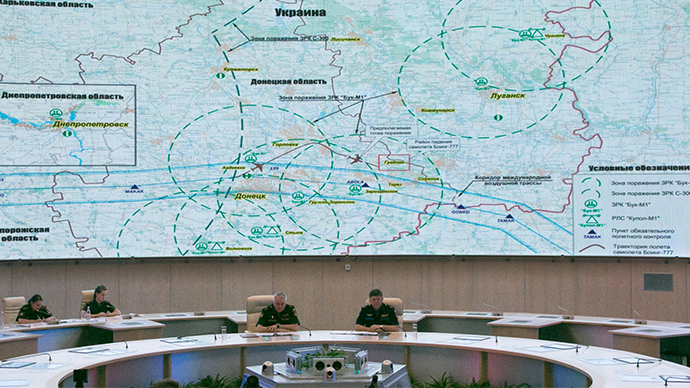
Russia has released military monitoring data, which shows Kiev military jets tracking the MH17 plane shortly before the crash - and posed yet another set of questions to Ukraine and the US over the circumstances of the tragedy.
รัสเซียเผยข้อมูลการเฝ้าติดตามทางทหาร ที่แสดงให้เห็นว่า เครื่องบินทหารเคียฟ บินติดตามเครื่องบิน MH17 ก่อนที่เครื่องจะตก และ เพิ่มเติมชุดคำถามต่อยูเครนและสหรัฐในประเด็นสภาพการณ์แวดล้อมของการเกิดโศกนาฏกรรมดังกล่าว
1. Why did the MH17 plane leave the international corridor?
“Please note that the plane stayed within the corridor until it reached Donetsk but then it deviated from the route to the north,” said Kartopolov.
๑.ด้วยเหตุใดเครื่องบิน MH17 จึงได้เบี่ยงออกนอกเส้นทางจราจรทางอากาศสากล?
"สังเกตุว่า เครื่องบินยังคงบินอยู่ในเส้นทางปกติ จนกระทั่งเครื่องบินบินมาถึงเมือง โดเนสก์ จากนี้ไปเครื่องบินก็ได้เบี่ยงออกจากเส้นทางบินไปทางเหนือ"...
2. Was MH17 leaving the route a navigation mistake or was the crew following instructions by Ukrainian air traffic controllers in Dnepropetrovsk?
“The maximum deviation from the left border of the corridor was 14 km. Following that, we can see the plane maneuvering to return to the corridor, yet the Malaysian crew did not get a chance to complete the maneuver. At 17.20, the plane began to lose speed, and at 17.23 it disappeared from Russian radars.”
๒.การออกนอกเส้นทางบินของ MH17 เกิดจากความผิดพลาดในการนำร่อง หรือ นักบินทำตามคำแนะนำที่ได้รับจากหอบังคับการบินยูเครนที่ ดเนปรอเปตรอฟสก์?
"การเบี่ยงเบนจากขอบทางซ้ายของเส้นทางบินคือ 14 กิโลเมตร , หลังจากนั้น เราเห็นเครื่องบินพยายามกลับเข้าสู่เส้นทางบินปกติ ทว่านักบินของ มาเลเซีย ไม่มีโอกาสได้กระทำการจนสำเร็จ ณ เวลา 17:20น. เครื่องบินก็เริ่มสูญเสียความเร็ว และ ในเวลา 17:23น. มันก็หายไปจากจอเรด้าของรัสเซีย"
3. Why was a large group of air defense systems deployed to the militia-held area if the self-defense forces have no planes?
“As far as we know, the Ukrainian military had three or four air defense battalions equipped with Buk-M1 SAM systems deployed in the vicinity of Donetsk on the day of the crash. This system is capable of hitting targets within the range of 35 km at the altitude of up to 22 km.”
Buk missile defense units in Donetsk Region, 5km north of Donetsk city, on July 14, 2014. (RIA Novosti)Buk missile defense units in Donetsk Region, 5km north of Donetsk city, on July 14, 2014. (RIA Novosti)
๓.เหตุใดระบบป้องกันภัยทางอากาศจำนวนมากถูกปล่อยเข้าปฏิบัติการในพื้นที่ยึดครองของกองกำลังติดอาวุธ ในเมื่อกองกำลังเหล่านี้ไม่มี อากาศยาน
"เท่าที่เราทราบ กองทัพยูเครนมีกองพันทหารต่อสู้อากาศยานติดตั้งระบบต่อต้านอากาศยาน BUK-M1 SAM จำนวน 3-4 กองพันออกปฏิบัติการอยู่บริเวณใกล้เคียงเมือง โดเนสก์ ในวันที่เกิดการตก ตัวระบบมีขีดความสามารถโจมตีเป้าหมายได้ในระยะ 35 กิโลเมตร ที่ระดับความสูงถึง 22 กิโลเมตร"
4. Why did Kiev deploy BUK missile systems on the edge of militia-controlled zones directly before the tragedy?
“We have satellite photos of the places where Ukraine had its air defense units deployed in the southeastern parts of the country. The first three photos were made on July 14. The first photo shows Buk launchers 8 km northwest of Lugansk. You can clearly see a TELAR and two TELs. The second photo shows radars 5 km north of Donetsk. You can see two TARs along with other equipment and technical structures. The third photo shows air defense systems north of Donetsk. You can clearly see a TELAR launcher and about 60 military and auxiliary vehicles, tents for vehicles and other structures.
๔.เหตุใดเคียฟนำระบบขีปนาวุธ BUK ออกปฏิบัติการบริเวณรอยต่อเขตยึดครองของกองกำลังติดอาวุธ ทันทีก่อนเกิดโศกนาฏกรรม?
"เรามีภาพถ่ายดาวเทียมสถานที่ที่ยูเครนจัดวางระบบป้องกันภัยทางอากาศในภูมิภาคตะวันออกเฉียงใต้ของประเทศ ...... (ข้อมูลเหมือนเมื่อวาน)"
“Here’s a photo of the same area made on July 17. Please note that the launcher has disappeared. The fifth photo shows a battery of Buk missiles at the village of Zaroshchenskoye 50 km east of Donetsk and 8 km south of Shakhtyorsk on the morning of the same day. The sixth photo shows the same area on July 18. As you can see, the battery has left.”
No Buk missile defense units in Donetsk Region, 5km north of Donetsk city, on July 17, 2014. (RIA Novosti)No Buk missile defense units in Donetsk Region, 5km north of Donetsk city, on July 17, 2014. (RIA Novosti)
(ข้อมูลเหมือนเมื่อวาน)
5. On the day of the crash Kiev intensified Kupol-M1 9S18 radar activity, key BUK system components. Why?
“Also, July 17 saw increased activity on the part of Ukraine’s Kupol-M1 9S18 radars, which are part of the Buk system. Here on this chart you see that there were seven radars operating on July 15, eight radars operating on July 16, and nine radars operating on July 17 in the area. Then, starting with July 18, the intensity of radar activities radically decreased, and now there are no more than two or three radars operating a day. The reason behind this is yet to be found.”
๕.ในวันเกิดการตก เคียฟเพิ่มความเข้มข้นในการปฏิบัติงาน เรด้า กูโปล-M1 9S18 , ส่วนประกอบที่เป็นกุญแจสำคัญของระบบ BUK , ทำไม? (ข้อมูลเหมือนเมื่อวาน)

MH17:ข่าว: 10 คำถามเพิ่มเติมจากกองทัพรัสเซีย ยื่นต่อยูเครนและสหรัฐในเรื่องการตกของ MH17
10 more questions Russian military pose to Ukraine, US over MH17 crash
10 คำถามเพิ่มเติมจากกองทัพรัสเซีย ยื่นต่อยูเครนและสหรัฐในเรื่องการตกของ MH17
Published time: July 21, 2014 23:23
Edited time: July 22, 2014 13:56 Get short URL
Russia Military at the media conference in Moscow,
Russia has released military monitoring data, which shows Kiev military jets tracking the MH17 plane shortly before the crash - and posed yet another set of questions to Ukraine and the US over the circumstances of the tragedy.
รัสเซียเผยข้อมูลการเฝ้าติดตามทางทหาร ที่แสดงให้เห็นว่า เครื่องบินทหารเคียฟ บินติดตามเครื่องบิน MH17 ก่อนที่เครื่องจะตก และ เพิ่มเติมชุดคำถามต่อยูเครนและสหรัฐในประเด็นสภาพการณ์แวดล้อมของการเกิดโศกนาฏกรรมดังกล่าว
1. Why did the MH17 plane leave the international corridor?
“Please note that the plane stayed within the corridor until it reached Donetsk but then it deviated from the route to the north,” said Kartopolov.
๑.ด้วยเหตุใดเครื่องบิน MH17 จึงได้เบี่ยงออกนอกเส้นทางจราจรทางอากาศสากล?
"สังเกตุว่า เครื่องบินยังคงบินอยู่ในเส้นทางปกติ จนกระทั่งเครื่องบินบินมาถึงเมือง โดเนสก์ จากนี้ไปเครื่องบินก็ได้เบี่ยงออกจากเส้นทางบินไปทางเหนือ"...
2. Was MH17 leaving the route a navigation mistake or was the crew following instructions by Ukrainian air traffic controllers in Dnepropetrovsk?
“The maximum deviation from the left border of the corridor was 14 km. Following that, we can see the plane maneuvering to return to the corridor, yet the Malaysian crew did not get a chance to complete the maneuver. At 17.20, the plane began to lose speed, and at 17.23 it disappeared from Russian radars.”
๒.การออกนอกเส้นทางบินของ MH17 เกิดจากความผิดพลาดในการนำร่อง หรือ นักบินทำตามคำแนะนำที่ได้รับจากหอบังคับการบินยูเครนที่ ดเนปรอเปตรอฟสก์?
"การเบี่ยงเบนจากขอบทางซ้ายของเส้นทางบินคือ 14 กิโลเมตร , หลังจากนั้น เราเห็นเครื่องบินพยายามกลับเข้าสู่เส้นทางบินปกติ ทว่านักบินของ มาเลเซีย ไม่มีโอกาสได้กระทำการจนสำเร็จ ณ เวลา 17:20น. เครื่องบินก็เริ่มสูญเสียความเร็ว และ ในเวลา 17:23น. มันก็หายไปจากจอเรด้าของรัสเซีย"
3. Why was a large group of air defense systems deployed to the militia-held area if the self-defense forces have no planes?
“As far as we know, the Ukrainian military had three or four air defense battalions equipped with Buk-M1 SAM systems deployed in the vicinity of Donetsk on the day of the crash. This system is capable of hitting targets within the range of 35 km at the altitude of up to 22 km.”
Buk missile defense units in Donetsk Region, 5km north of Donetsk city, on July 14, 2014. (RIA Novosti)Buk missile defense units in Donetsk Region, 5km north of Donetsk city, on July 14, 2014. (RIA Novosti)
๓.เหตุใดระบบป้องกันภัยทางอากาศจำนวนมากถูกปล่อยเข้าปฏิบัติการในพื้นที่ยึดครองของกองกำลังติดอาวุธ ในเมื่อกองกำลังเหล่านี้ไม่มี อากาศยาน
"เท่าที่เราทราบ กองทัพยูเครนมีกองพันทหารต่อสู้อากาศยานติดตั้งระบบต่อต้านอากาศยาน BUK-M1 SAM จำนวน 3-4 กองพันออกปฏิบัติการอยู่บริเวณใกล้เคียงเมือง โดเนสก์ ในวันที่เกิดการตก ตัวระบบมีขีดความสามารถโจมตีเป้าหมายได้ในระยะ 35 กิโลเมตร ที่ระดับความสูงถึง 22 กิโลเมตร"
4. Why did Kiev deploy BUK missile systems on the edge of militia-controlled zones directly before the tragedy?
“We have satellite photos of the places where Ukraine had its air defense units deployed in the southeastern parts of the country. The first three photos were made on July 14. The first photo shows Buk launchers 8 km northwest of Lugansk. You can clearly see a TELAR and two TELs. The second photo shows radars 5 km north of Donetsk. You can see two TARs along with other equipment and technical structures. The third photo shows air defense systems north of Donetsk. You can clearly see a TELAR launcher and about 60 military and auxiliary vehicles, tents for vehicles and other structures.
๔.เหตุใดเคียฟนำระบบขีปนาวุธ BUK ออกปฏิบัติการบริเวณรอยต่อเขตยึดครองของกองกำลังติดอาวุธ ทันทีก่อนเกิดโศกนาฏกรรม?
"เรามีภาพถ่ายดาวเทียมสถานที่ที่ยูเครนจัดวางระบบป้องกันภัยทางอากาศในภูมิภาคตะวันออกเฉียงใต้ของประเทศ ...... (ข้อมูลเหมือนเมื่อวาน)"
“Here’s a photo of the same area made on July 17. Please note that the launcher has disappeared. The fifth photo shows a battery of Buk missiles at the village of Zaroshchenskoye 50 km east of Donetsk and 8 km south of Shakhtyorsk on the morning of the same day. The sixth photo shows the same area on July 18. As you can see, the battery has left.”
No Buk missile defense units in Donetsk Region, 5km north of Donetsk city, on July 17, 2014. (RIA Novosti)No Buk missile defense units in Donetsk Region, 5km north of Donetsk city, on July 17, 2014. (RIA Novosti)
(ข้อมูลเหมือนเมื่อวาน)
5. On the day of the crash Kiev intensified Kupol-M1 9S18 radar activity, key BUK system components. Why?
“Also, July 17 saw increased activity on the part of Ukraine’s Kupol-M1 9S18 radars, which are part of the Buk system. Here on this chart you see that there were seven radars operating on July 15, eight radars operating on July 16, and nine radars operating on July 17 in the area. Then, starting with July 18, the intensity of radar activities radically decreased, and now there are no more than two or three radars operating a day. The reason behind this is yet to be found.”
๕.ในวันเกิดการตก เคียฟเพิ่มความเข้มข้นในการปฏิบัติงาน เรด้า กูโปล-M1 9S18 , ส่วนประกอบที่เป็นกุญแจสำคัญของระบบ BUK , ทำไม? (ข้อมูลเหมือนเมื่อวาน)